The Torpoint Archives is a registered Charity: 1043650
President: Tremayne Carew-Pole
The Torpoint Archives is a registered Charity: 1043650
President: Tremayne Carew-Pole
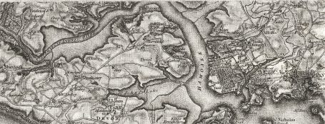
Believed to be the first O.S. map of S.E. Cornwall and S.W. Devon. c1850. Drawn up after the completion of the Breakwater (1841) but before completion of Tregantle Fort (1865).
We need your consent to load the translations
We use a third-party service to translate the website content that may collect data about your activity. Please review the details in the privacy policy and accept the service to view the translations.